
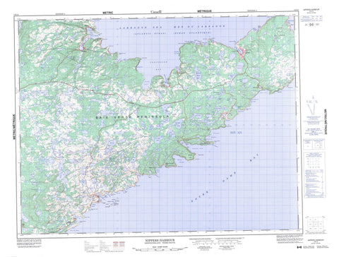
002E13 Nippers Harbour Canada topo map, 1:50,000 scale
002E13 Nippers Harbour NRCAN topographic map.
Includes UTM and GPS geographic coordinates (latitude and longitude). This 50k scale map is suitable for hiking, camping, and exploring, or you could frame it as a wall map.
Printed on-demand using high resolution, on heavy weight and acid free paper, or as an upgrade on a variety of synthetic materials.
Topos available on paper, Waterproof, Poly, or Tyvek. Usually shipping rolled, unless combined with other folded maps in one order.
- Product Number: NRCAN-002E13
- Parent Topo: TOPO-002E
- Map ID also known as: 002E13, 02E13, 2E13
- Unfolded Size: Approximately 26" high by 36" wide
- Weight (paper map): ca. 55 grams
- Map Type: POD NRCAN Topographic Map
- Map Scale: 1:50,000
- Geographical region: Newfoundland and Labrador, Canada
Neighboring Maps:
All neighboring Canadian topo maps are available for sale online at 1:50,000 scale.
Purchase the smaller scale map covering this area: Topo-002E
Spatial coverage:
Topo map sheet 002E13 Nippers Harbour covers the following places:
- Balsam Bud Cove - Bateaux Cove - Bear Cove - Beaver Cove - Betts Bight - Betts Cove - Big Cove - Bobby Cove - Brent's Cove - Buttonhole Cove - Confusion Bay - Duggins Tilt Cove - East Stocking Harbour - Goelettes Bay - Gooseberry Cove - Grand Cove - Great Caplin Cove - Green Cove - Harbour Round - Hill Graplin Cove - Hollin Cove - Indian Burying Ground Cove - La Scie Harbour - Little Bay - Little Caplin Cove - Little Pacquet - Long Point Cove - Martins Cove - Ming's Bight - Nippers Harbour - Noble Cove - Northwest Arm - Northwest Arm - Notre Dame Bay - Pacquet Harbour - Pittman Bight - Ragged Cove - Reddits Cove - Rogues Harbour - Round Harbour - Seal Island Bight - Shoe Cove - Snooks Arm - Southwest Arm - Stocking Harbour - Tilt Cove - Venams Bight - Welshs Bight - White Cove - Wild Bight - Wild Cove - Sandy Beach - Baie Verte Peninsula - Bear Cove Head - Beaver Cove Head - Betts Head - Bigrel Point - Blanche Point - Bluff Point - Brent Cove Head - Broussailles Point - Candlemas Head - Cape Brulé - Cape Cagnet - Cape Canis - Cape Coup de Hache - Fishing Point - Gooseberry Cove Head - Green Head - Green Point - Hammer Head - Harbour Point - Hill Graplin Head - Humann Point - Jigging Head - Long Point - Lower Bill - Major Point - Marchal Point - Mouse Point - Noble Head - Pelée Point - Pigeon Cove Head - Ragged Point - Reddits Point - Rogues Harbour Point - Rouge Point - Round Harbour Head - Salmon Point - Scrape Point - Sleepy Lion Point - Sleepy Point - Snooks Head - Soup Point - Vails Point - Betts Island - Brandy Islands - Duck Island - Fox Island - Green Island - Gull Island - Nippers Islands - Pigeon Island - Riding Island - Seal Island - Seal Island - Armchair Pond - Bar Pond - Beaver Cove Pond - Beaver Pond - Belly Pond - Betts Big Pond - Binch Pond - Blackhead Pond - Burtons Big Pond - Burtons Pond - Buskam Pond - Camp Pond - Cunningham Pond - Dump Pond - East Pond - Father Sheehan Pond - Forth Pond - Glass Hill East Pond - Glass Hill West Pond - Goat Pond - Gold Pond - Goss Pond - Greenwood Pond - Gull Pond - Harbour Round Pond - Kitty Pond - L Camp Pond - Little Stakes Pond - Long Pond - Long Pond - Loon Pond - Mathis Pond - Mill Pond - Nippers Harbour Pond - Noble Pond - North Yak Lake - Peridot Lake - Pine Pond - Red Cliff Pond - Rocky Pond - Saddler Pond - Settler Pond - Side Pond - Sister Pond - Snooks Arm Pond - South Yak Lake - Southwest Pond - Stakes Pond - The Sisters - The Sisters - Tilt Pond - Welshs Pond - West Pond - Windsor Lake - Winser Lake - Bare Range - Black Lookout - Chips Hill - Crows Nest - Gros Morne - Red Cliff Hills - Pacquet Brook - Alexander Rock - Crocodile Shoal - Gull Rock - Mother Howe Bank - Ross Rock - Shoe Cove Rock - Sutherland Bank - West Ice Ledge - White Patch - Brent's Cove - Burlington - La Scie - LaScie - Nippers Harbour - Pacquet - Tilt Cove - Woodstock - Bobby Cove - Harbour Round - Indian Burying Place - Rouge Harbour - Round Harbour - Shoe Cove - Shoe Cove Bight - Snooks Arm


