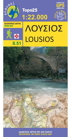
Lousios (1:25 000) Hiking Map
A hiking map for Lousios in scale 1:22 000
Lousios (Loussios) Gorge in the center of Peloponnese on a contoured and GPS compatible map at 1:22 000, printed on light, waterproof and tear-resistant synthetic paper. Coverage extends from Dimitsana southwards to Karitena, and includes Stemnitsa with Klinitsa and the adjoining peaks. Lousios gorge is a small canyon with beautiful monasteries nested in the rock situated in a beautiful region in the heart of the Peloponnese, in Arcadia. Near Dimitsana, there is the Water Power Museum and many watermills.
On one side is a topographic map of the area with contours at 20m intervals and bold altitude colouring. The map shows local footpaths and trails, including the route along the river gorge. Road network indicates dirt roads in poor condition, shows distances on main routes, and gives locations of petrol stations. Symbols highlight various places of interest, including churches, museums, archaeological sites, viewpoints, etc. The
- Product Number: ANA_LOUSIOS_HIKE_13
- Reference Product Number: - None -
- ISBN: 9789608195295
- Date of Publication: 1/1/2013
- Folded Size: 9.4 inches high by 4.4 inches wide
- Unfolded (flat) Size: 26.6 inches high by 18.8 inches wide
- Map format: Folded
- Map type: Trade Maps - Hiking
- Geographical region: Greece