
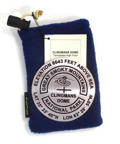
Clingmans Dome, Great Smoky Mountains National Park, North Carolina paperweight
3 1/4 inch diameter
Cast in fine pewter
Felt backing
With soft fleece pouch
In clear-vinyl covered box
PLACE NAME: Clingmans Dome
ELEVATION: 6,643 ft.
COORDINATES: N35° 33 46 W83° 29 55
LOCATION: Great Smoky Mountains National Park, USA
At 6,643 feet, Clingmans Dome is the highest point in the Great Smoky Mountains National Park. It is the highest point in Tennessee, and the third highest point in the Appalachian Mountain range. Only Mt. Mitchell (6,684 feet) and Mt. Craig (6,647) in Mt. Mitchell State Park rise higher. Clingmans Dome is a popular park destination. Spectacular vistas await those willing to climb a 30-minute steep half-mile walk to the tower at the top. On clear, pollution-free days, views expand over 100 miles.
- Product Number: GSU_PW_CLING
- Reference Product Number: 2306089M
- ISBN: - None -
- Map format: - None -
- Map type: Accessories - Other Accessories
- Geographical region: United States
- Geographical subregion: North Carolina,Tennessee


