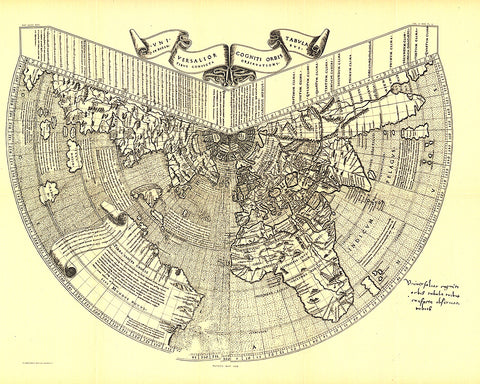
1893 Ruysch 1508 Map
One of the first maps of the new world, Johannes Ruysch made this map, using a polar projection, which includes an extensive view of South America, islands of the West Indies, and a portion of North America. The World Map from Ruysch appeared for the first time among the Tabulae Novae in some copies of the 1507 Rome edition of Ptolemys Geography. Ruyschs map illustrates a number of significant geographic features more correctly than before, especially along the easterly sea route to the Orient which was of prime importance to early sixteenth-century Europeans. An incredible historical piece.
- Product Number: PODHNG_WOR_1508_93
- Reference Product Number: 2321518M
- ISBN: - None -
- Date of Publication: ###############################################################################################################################################################################################################################################################
- Unfolded (flat) Size: 18.25 inches high by 22.75 inches wide
- Map format: Wall
- Map type: Trade Maps - Historical