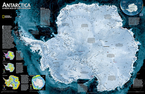
Antarctica Satellite, Sleeved by National Geographic Maps
Click to Zoom (high resolution)
A striking view of Antarcticas terrain, compiled from 4,500 satellite scans. Additional inset maps show surface elevation, ice sheet thickness, velocity of ice flow, and sea ice movement and windflow.
- Product Number: 2130624M
- Product Code: NG_ANT_WA_S
- Publisher Product ID: RE00620091
- ISBN: 9780792285885
- Year of Publication: 2010
- Unfolded Size: 20.08 x 31.1 inches
- Map type: Wall Map
- Geographical region: Antarctica