
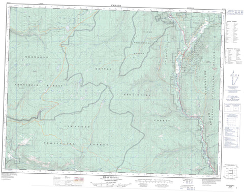
082E06 Beaverdell Canada topo map, 1:50,000 scale
082E06 Beaverdell NRCAN topographic map.
Includes UTM and GPS geographic coordinates (latitude and longitude). This 50k scale map is suitable for hiking, camping, and exploring, or you could frame it as a wall map.
Printed on-demand using high resolution, on heavy weight and acid free paper, or as an upgrade on a variety of synthetic materials.
Topos available on paper, Waterproof, Poly, or Tyvek. Usually shipping rolled, unless combined with other folded maps in one order.
- Product Number: NRCAN-082E06
- Parent Topo: TOPO-082E
- Map ID also known as: 082E06, 82E6, 82E06
- Unfolded Size: Approximately 26" high by 36" wide
- Weight (paper map): ca. 55 grams
- Map Type: POD NRCAN Topographic Map
- Map Scale: 1:50,000
- Geographical region: British Columbia, Canada
Neighboring Maps:
All neighboring Canadian topo maps are available for sale online at 1:50,000 scale.
Purchase the smaller scale map covering this area: Topo-082E
Spatial coverage:
Topo map sheet 082E06 Beaverdell covers the following places:
- Similkameen Division Yale Land District - Allendale Lake - Culper Lake - Derenzy Lake - Heart Lake - McLean Clan Lake - Patch Lake - Saunier Lake - Solco Lake - Tuzo Lake - Beaverdell Range - Cranberry Ridge - Crystal Butte - Crystal Mountain - Curry Mountain - Goat Peak - King Solomon Mountain - Mount Christie - Mount Wallace - Okanagan Highland - Regional District of Central Kootenay - Regional District of Kootenay-Boundary - Réserve nationale de faune de Vaseux-Bighorn - Vaseux-Bighorn National Wildlife Area - Interior Plateau - Beaverdell Creek - Big Goat Creek - Boomerang Creek - Boyer Creek - Carmi Creek - Chenier Creek - Colby Creek - Crystal Creek - Curry Creek - Derenzy Creek - Dominion Creek - Dutton Creek - Ellis Creek - Eugene Creek - Hay Creek - Horse Creek - Irrigation Creek - Job Creek - Kamloops Creek - Kelly River - Kilmer Creek - La Porte Creek - Little Goat Creek - Logan Creek - Matheson Creek - Maurice Creek - McIntyre Creek - McLean Creek - Morris Creek - Nelse Creek - North Ellis Creek - Richelieu Creek - Saunier Creek - Shuttleworth Creek - Solco Creek - South Ellis Creek - St. John Creek - Steward Creek - Susap Creek - Taurus Creek - Thomas Creek - Tuzo Creek - Vaseux Creek - Wallace Creek - West Kettle River - Westkettle River - Beaverdell - Carmi - Dellwye - Taurus - Venner Meadows


