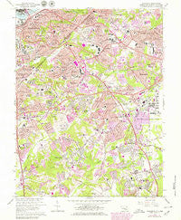
~ Anacostia DC topo map, 1:24000 scale, 7.5 X 7.5 Minute, Historical, 1965, updated 1979
Anacostia, District of Columbia, USGS topographic map dated 1965.
Includes geographic coordinates (latitude and longitude). This topographic map is suitable for hiking, camping, and exploring, or framing it as a wall map.
Printed on-demand using high resolution imagery, on heavy weight and acid free paper, or alternatively on a variety of synthetic materials.
Topos available on paper, Waterproof, Poly, or Tyvek. Usually shipping rolled, unless combined with other folded maps in one order.
- Product Number: USGS-5389826
- Free digital map download (high-resolution, GeoPDF): Anacostia, District of Columbia (file size: 18 MB)
- Map Size: please refer to the dimensions of the GeoPDF map above
- Weight (paper map): ca. 55 grams
- Map Type: POD USGS Topographic Map
- Map Series: HTMC
- Map Verison: Historical
- Cell ID: 916
- Scan ID: 255996
- Imprint Year: 1979
- Woodland Tint: Yes
- Photo Revision Year: 1979
- Aerial Photo Year: 1977
- Edit Year: 1979
- Field Check Year: 1956
- Datum: NAD27
- Map Projection: Polyconic
- Map published by United States Geological Survey
- Map Language: English
- Scanner Resolution: 600 dpi
- Map Cell Name: Anacostia
- Grid size: 7.5 X 7.5 Minute
- Date on map: 1965
- Map Scale: 1:24000
- Geographical region: District of Columbia, United States
Neighboring Maps:
All neighboring USGS topo maps are available for sale online at a variety of scales.
Spatial coverage:
Topo map Anacostia, District of Columbia, covers the geographical area associated the following places:
- Marlow Heights - Fort Dupont - Silver Hill - Arnold Heights - Dillon Park - Pagetts Corner - Congress Park - Coral Hills - Berkshire - Dupont Park - Palmers Corner - Parkland Terrace - Glassmanor - Woodland - Buena Vista - Naylor Gardens - Randle Highlands - Friendly - Bradbury Heights - Dupont Heights - Fort Davis - Deer Park Heights - Barnaby Terrace - Potomac City (historical) - Fairfax Village - Gordons Corner - Suitland - Anacostia - Hyde Field Estates - Woods Corner - Forest Manor - Douglass Dwellings - Oxon Run Hills - Andrews Manor - Colebrooke - West Over View - Garfield Heights - Shipley Terrace - Oakland - Oaklawn - District Heights - Manchester Estates - Murray Hill - Hillside - Knox Hill Dwellings - Bradbury Park - Temple Hills Park - Squires Woods - Friendly Hills - Good Hope - Middleton Farm - Twining - North Forestville - Washington Highlands - Camp Springs - Clinton - Barry Farms - Penn Branch - Pennsylvania Avenue Hights - Phelps Corner - Parkland - Apple Grove - Ballard - Broad Creek - Hillcrest - Rosecroft Park - Jenkins Corner - Forest Heights - Broadview - South Lawn - Hunts Corner - Barnaby Manor Oaks - Temple Hills - Hillcrest Heights - North Barnaby - Boulevard Heights - Kastle Estates - Morningside - Suitland Manor - Oxon Hill - Auth Village - Fairlawn - Waggaman Heights - Silver Hill Park
- Map Area ID: AREA38.87538.75-77-76.875
- Northwest corner Lat/Long code: USGSNW38.875-77
- Northeast corner Lat/Long code: USGSNE38.875-76.875
- Southwest corner Lat/Long code: USGSSW38.75-77
- Southeast corner Lat/Long code: USGSSE38.75-76.875
- Northern map edge Latitude: 38.875
- Southern map edge Latitude: 38.75
- Western map edge Longitude: -77
- Eastern map edge Longitude: -76.875