
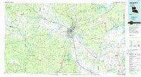
~ Alexandria LA topo map, 1:100000 scale, 30 X 60 Minute, Historical, 1986, updated 1986
Alexandria, Louisiana, USGS topographic map dated 1986.
Includes geographic coordinates (latitude and longitude). This topographic map is suitable for hiking, camping, and exploring, or framing it as a wall map.
Printed on-demand using high resolution imagery, on heavy weight and acid free paper, or alternatively on a variety of synthetic materials.
Topos available on paper, Waterproof, Poly, or Tyvek. Usually shipping rolled, unless combined with other folded maps in one order.
- Product Number: USGS-5595056
- Free digital map download (high-resolution, GeoPDF): Alexandria, Louisiana (file size: 23 MB)
- Map Size: please refer to the dimensions of the GeoPDF map above
- Weight (paper map): ca. 55 grams
- Map Type: POD USGS Topographic Map
- Map Series: HTMC
- Map Verison: Historical
- Cell ID: 67028
- Scan ID: 335150
- Imprint Year: 1986
- Woodland Tint: Yes
- Aerial Photo Year: 1981
- Edit Year: 1986
- Datum: NAD27
- Map Projection: Universal Transverse Mercator
- Planimetric: Yes
- Map published by United States Geological Survey
- Map Language: English
- Scanner Resolution: 600 dpi
- Map Cell Name: Alexandria
- Grid size: 30 X 60 Minute
- Date on map: 1986
- Map Scale: 1:100000
- Geographical region: Louisiana, United States
Neighboring Maps:
All neighboring USGS topo maps are available for sale online at a variety of scales.
Spatial coverage:
Topo map Alexandria, Louisiana, covers the geographical area associated the following places:
- Moreland - Lee Heights - Kingsville - Sartori (historical) - Chambers - Tioga - Jericho - Lena - Leander - Vortex (historical) - Holloway - Ravencamp - Green Gables - Moller - Galbraith - Samtown - Lacamp - Moncla - Midway - Boyce - Garnett (historical) - Hood - Ball - Kateland - Magnolia Park - Effie - Cora - Prospect - Fairmount - Lamourie - Wises (historical) - Clifton - Lecompte - Latanier - Marksville - Timber Trails - Elmelhine - Morris (historical) - Woodworth - Cedar Grove - Chopin - Buckeye - Echo - Elmer - Stonewalls (historical) - Belle d'Eau - Simms - Pineville Junction - Castor Plunge - Mead (historical) - Sampusand - Gardner - Oasis - Sieps - Whittington - Hicks Crossing - Kincaid (historical) - Wardville - Lewiston - Alfalfa - Meeker - Cloverdale - Melder - Cheneyville - Thomas (historical) - Montcla - Oklahoma - Weil - Milford (historical) - Afeman - Mora - Rapides - Wilda - Jacksonville (historical) - Fitzgerald (historical) - Walding - Fort Randolph - Crane - Libuse - Stay - Bijou - Inglewood - Mansura - Witchwood (historical) - Price Crossing - Poland - Hot Wells - Loyd - Cocoville - Oden (historical) - Richland (historical) - Sieper - Otis - Wilson Point - Rock - Creola - Dunlap - Driftwood Trailer Park - Pine Coupee - Center Point
- Map Area ID: AREA31.531-93-92
- Northwest corner Lat/Long code: USGSNW31.5-93
- Northeast corner Lat/Long code: USGSNE31.5-92
- Southwest corner Lat/Long code: USGSSW31-93
- Southeast corner Lat/Long code: USGSSE31-92
- Northern map edge Latitude: 31.5
- Southern map edge Latitude: 31
- Western map edge Longitude: -93
- Eastern map edge Longitude: -92


