
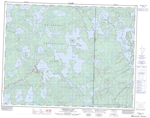
052L03 Crowduck Lake Canada topo map, 1:50,000 scale
052L03 Crowduck Lake NRCAN topographic map.
Includes UTM and GPS geographic coordinates (latitude and longitude). This 50k scale map is suitable for hiking, camping, and exploring, or you could frame it as a wall map.
Printed on-demand using high resolution, on heavy weight and acid free paper, or as an upgrade on a variety of synthetic materials.
Topos available on paper, Waterproof, Poly, or Tyvek. Usually shipping rolled, unless combined with other folded maps in one order.
- Product Number: NRCAN-052L03
- Parent Topo: TOPO-052L
- Map ID also known as: 052L03, 52L3, 52L03
- Unfolded Size: Approximately 26" high by 36" wide
- Weight (paper map): ca. 55 grams
- Map Type: POD NRCAN Topographic Map
- Map Scale: 1:50,000
- Geographical region: Manitoba, Canada
Neighboring Maps:
All neighboring Canadian topo maps are available for sale online at 1:50,000 scale.
Purchase the smaller scale map covering this area: Topo-052L
Spatial coverage:
Topo map sheet 052L03 Crowduck Lake covers the following places:
- Big Northern Bay - Halley's Bay - Horseshoe Bay - Scot Bay - Castaway Point - Poplar Narrows - Crowduck Falls - South Boundary Falls - Noyon - Rudd - Islington Indian Reserve 29 - Réserve indienne Islington 29 - Wabaseemoong 29 - Bostrom Island - Boundary Island - Brune Island - Godsmark Island - Malcom Island - One Island - Post Island - Scholey Island - Akeroyd Lake - Bagguley Lake - Beck Lake - Bedford Lake - Big Whiteshell Lake - Boon Lake - Coulombe Lake - Crowduck Lake - Duthoit Lake - Eaglenest Lake - Eaglenest Lake - Echo Lake - Forbes Lake - Fryatt Lake - George Lake - Goose Lakes - Green Lake - Hawken Lake - Hemenway Lake - Hop Lake - Horseshoe Lake - Jadel Lake - Jadel Lake - Jessica Lake - Lahoda Lake - Leitch Lake - Little Echo Lake - Little Lake - Little Whiteshell Lake - Lone Island Lake - Luce Lake - Malloy Lake - Mantario Lake - Meditation Lake - Middleton Lake - Mocassin Lake - Musk Lake - Musk Lake - North Sailing Lake - North Scot Lake - Olynyk Lake - One Lake - Rae Lake - Ritchey Lake - Ruthig Lake - Saddle Lake - Segal Lake - Shakeshaft Lake - Sheep Lake - Side Saddle Lake - Sutcliffe Lake - Swamp Lake - Tetu Lake - Three Lake - Tuber Lake - Tugby Lake - Turtle Lake - Two Lake - Vier Lake - Whiteshell Lake - Zytaruk Lake - Castle Rock - Musk Lake Conservation Reserve - Whiteshell Provincial Forest - Whiteshell Provincial Park - Manitoba - Bedford Creek - Bernard Creek - Crowduck Creek - Dean Creek - English River - Fraser Creek - Indian Creek - Jadel Creek - Rivière Winnipeg - Rivière Winnipeg - Scot River - Tie Creek - Whiteshell River - Winnipeg River - Winnipeg River - La Vérendrye Trail - Big Whiteshell Lake


