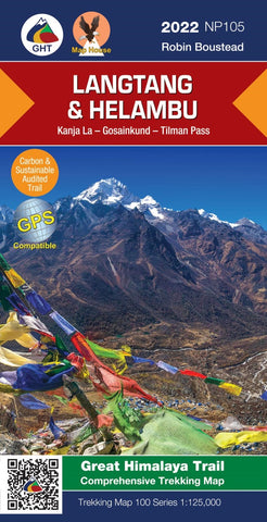
Langtang & Helambu: Gosainkund & Helambu
Langtang and Helambu, map no. 105, at 1:125,000 on a waterproof and tear-resistant trekking map from the Himalayan MapHouse in their series covering the whole of northern Nepal. The map highlights main trekking routes north of Kathmandu, including Gosainkund Trek, Kangja la – Naya Kanga trek, Paldor Trek, Tamang Heritage Trek, Bhairav Kund Trek, and the relevant sections of the GHT Cultural Trail and the GHT High Route. Contours are at 80m intervals. Route profile shows the Langtang section of the GHT High Route between Syno Jyandan and Tipling.
Cartography in these waterproof editions, first published in 2011, is identical to what Himalayan MapHouse use in most maps in their other series, published under the Nepa Maps imprint. Contours are at intervals of 80m or 40m (please check individual descriptions), with relief shading plus colouring to show different types of terrain or vegetation. The maps show names of numerous chains, peaks glaciers, valleys, rivers, lakes, etc.
- Product Number: NEP_105_LANG_HEL_22
- Reference Product Number: - None -
- ISBN: 9789937956598
- Date of Publication: 12/1/2022
- Folded Size: 9.45 inches high by 4.72 inches wide
- Unfolded (flat) Size: 32.68 inches high by 22.83 inches wide
- Map format: Folded
- Map type: Trade Maps - Hiking
- Geographical region: Nepal