
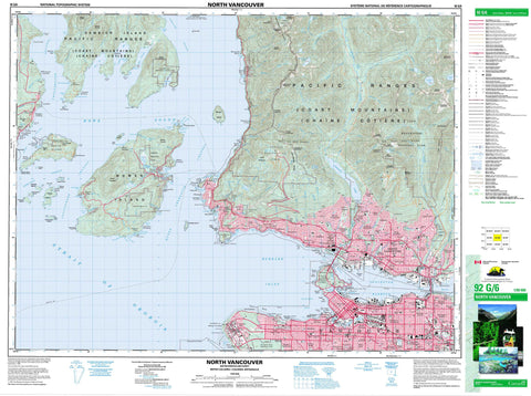
092G06 North Vancouver Canada topo map, 1:50,000 scale
092G06 North Vancouver NRCAN topographic map.
Includes UTM and GPS geographic coordinates (latitude and longitude). This 50k scale map is suitable for hiking, camping, and exploring, or you could frame it as a wall map.
Printed on-demand using high resolution, on heavy weight and acid free paper, or as an upgrade on a variety of synthetic materials.
Topos available on paper, Waterproof, Poly, or Tyvek. Usually shipping rolled, unless combined with other folded maps in one order.
- Product Number: NRCAN-092G06
- Parent Topo: TOPO-092G
- Map ID also known as: 092G06, 92G6, 92G06
- Unfolded Size: Approximately 26" high by 36" wide
- Weight (paper map): ca. 55 grams
- Map Type: POD NRCAN Topographic Map
- Map Scale: 1:50,000
- Geographical region: British Columbia, Canada
Neighboring Maps:
All neighboring Canadian topo maps are available for sale online at 1:50,000 scale.
Purchase the smaller scale map covering this area: Topo-092G
Spatial coverage:
Topo map sheet 092G06 North Vancouver covers the following places:
- Alberta Bay - Alder Cove - Andys Bay - Apodaca Cove - Arbutus Bay - Avalon Bay - Batchelor Cove - Bowen Bay - Brigade Bay - Brokers Bay - Burgess Cove - Burrard Inlet - Cates Bay - Caulfeild Cove - Centre Bay - Cliff Cove - Coal Harbour - Columbine Bay - Copper Cove - Cowards Cove - Deep Bay - Dorman Bay - Eagle Harbour - East Bay - Echo Cove - Enchanta Bay - English Bay - Fairweather Bay - False Creek - Fisherman Cove - Fishermans Cove - Galbraith Bay - Gambier Harbour - Grace Harbour - Grafton Bay - Halkett Bay - Horseshoe Bay - Howe Sound - King Edward Bay - Konishi Bay - Larsen Bay - Lions Bay - Lodge Cove - MacKenzie Cove - Mannion Bay - Mitchell Cove - Montevista Bay - Patterson Cove - Pilot Cove - Plumper Cove - Poca Cove - Port Graves - Robson Cove - Safety Bay - Safety Cove - Sandy Cove - Seymour Bay - Smugglers Cove - Snug Cove - Starboat Cove - Thornbrough Bay - Trinity Bay - Tunstall Bay - Union Bay - Union Cove - Vancouver Harbour - West Bay - West Bay - Wharf Cove - Whyte Cove - English Bay Beach - Jericho Beach - Kitsilano Beach - Point Grey Beach - Second Beach - September Morn Beach - Sunset Beach - Third Beach - Wreck Beach - Batchelor Point - Boulder Point - Brockton Point - Cape Roger Curtis - Carmelo Point - Cotton Point - Elsje Point - Erwin Point - Ferguson Point - Gambier Point - Halkett Point - Hood Point - Hope Point - Kettle Point - Kitsilano Point - Lookout Point - Navvy Jack Point - Noon Breakfast Point - Observatory Point - Point Atkinson - Point Cowan - Point Grey - Point No Point - Potts Point - Prospect Point - Reardon Point - Soames Point - Tyee Point - White Cliff Point - Whytecliff Point - Witherby Point - Barfleur Passage - Collingwood Channel - First Narrows - Queen Charlotte Channel - Ramillies Channel - Second Narrows - Shoal Channel - Strait of Georgia - Thornbrough Channel - North Vancouver - Vancouver - Indian Bluff - Steep Bluff - Bowen Island - North Vancouver - West Vancouver - Cypress Falls - Annieville Dike - Capilano Indian Reserve 5 - Chekwelp Indian Reserve 26 - Chekwelp Indian Reserve 26A - Mission Indian Reserve 1 - Réserve indienne Capilano 5 - Réserve indienne Chekwelp 26 - Réserve indienne Chekwelp 26A - Réserve indienne Mission 1 - Réserve indienne Schaltuuch 27 - Réserve indienne Seymour Creek 2 - Schaltuuch Indian Reserve 27 - Seymour Creek Indian Reserve 2 - Alexandra Island - Bird Islet - Bowen Island - Bowyer Island - Christie Islet - Cynthia Island - Deadman Island - Eagle Island - Finisterre Island - Gambier Island - Grace Islands - Granville Island - Grebe Islets - Hermit Island - Home Island - Home Island (Salmon Rock) - Hutt Island - Keats Island - Little Popham Island - Mickey Island - New Island - New Islet - Pasley Island - Passage Island - Popham Island - Preston Island - Ragged Island - Round Island - Shelter Islands - Shelter Islets - Twin Islands - Weyburn Island - White Island - Whyte Islet - Worlcombe Island - Beaver Lake - Burwell Lake - Capilano Lake - Cornett Lakes - Deeks Lakes - Dick Lake - Enchantment Lake - Grafton Lake - Honeymoon Lake - Josephine Lake - Kennedy Lake - Killarney Lake - Little Capilano Lake - Lost Lagoon - Lynn Lake - Macklin Lake - Palisade Lake - Rice Lake - Rodgers Lake - Rogers Lake - Trout Lake - Whyte Lake - Yew Lake - Black Mountain - Britannia Range - Brunswick Mountain - Carmichael Peak - Cathedral Mountain - Chaîne Côtière - Coast Mountains - Coliseum Mountain - Crown Mountain - Dam Mountain - Fannin Mountains - Fannin Range - Goat Mountain - Grouse Mountain - Hat Mountain - Hollyburn Mountain - Hollyburn Ridge - Little Goat Mountain - Lynn Peaks - Mount Artaban - Mount Burwell - Mount Collins - Mount Fromme - Mount Gardner - Mount Hanover - Mount Harvey - Mount Hollyburn - Mount Killam - Mount Liddell - Mount Strachan - Pacific Ranges - Sentinel Hill - Soames Hill - St. Marks Summit - Stony Hill - The Lions - The Needles - Unnecessary Mountain - Greater Vancouver Regional District - Apodaca Park - Christie Islet Bird Sanctuary - Cypress Park - Halkett Bay Marine Park - Halkett Bay Park - Lieu historique national du Canada du Parc-Stanley - Plumper Cove Marine Park - Plumper Cove Park - Refuge d'oiseaux de l'îlot Christie - Stanley Park National Historic Site of Canada - Cypress Mountain - Grouse Mountain - Alberta Creek - Bluff Creek - Brothers Creek - Capilano Creek - Capilano River - Centre Creek - Charles Creek - Coliseum Creek - Connolly Creek - Crown Creek - Cypress Creek - Daniels Creek - Davies Creek - Dean Creek - Dick Creek - Disbrow Creek - Dodds Creek - Eagle Creek - Eastcap Creek - Emerald Creek - Enchantment Creek - Explosives Creek - Fellowes Creek - Gibson Creek - Godman Creek - Grafton Creek - Guild Creek - Hadden Creek - Hanes Creek - Harvey Creek - Hastings Creek - Healmond Creek - Hesketh Creek - Honeymoon Creek - Houlgate Creek - Hutchinson Creek - Hydraulic Creek - Josephine Creek - Keith Creek - Kennedy Creek - Kill Creek - Killarney Creek - Kilmer Creek - Langdale Creek - Lawson Creek - Lee Creek - Lembke Creek - Loggers Creek - Lone Tree Creek - Lynn Creek - M (Yahoo) Creek - M Creek - Mackay Creek - Macklin Creek - Magnesia Creek - Malkin Creek - Mannion Creek - Marr Creek - May Creek - McDonald Creek - McDonald Creek - Montizambert Creek - Mosquito Creek - Nelson Creek - Newman Creek - Nickey Creek - Norvan Creek - Optimist Creek - Ouillet Creek - Palisade Creek - Pascoe Creek - Pipe Creek - Pitt Creek - Rodgers Creek - Rundle Creek - Sclufield Creek - Seymour Creek - Seymour River - Sisters Creek - Soames Creek - Still Creek - Strachan Creek - Strip Creek - Terminal Creek - Thain Creek - Thames Creek - Turner Creek - Turpin Creek - Vinson Creek - Wagg Creek - Warwick Creek - Westmount Creek - Whispering Creek - Whyte Creek - Wickenden Creek - Burnaby Shoal - Calamity Point - Gumboot Bank - Hutt Rock - Loch Katrine Bank - Mariners Rest - Neptune Bank - Pam Rock - Parthia Shoal - Siwash Rock - Spanish Bank - Steamboat Rock - Gibsons - Altamont - Ambleside - Arbutus Ridge - Ardley - Bowen Bay - British Properties - Brunswick - Brunswick Beach - Bundy - Burnaby Heights - Camp Artaban - Canyon Heights - Capilano - Capilano Highlands - Cascade Heights - Caulfeild - Cedardale - Cleveland Park - Cowans Point - Cypress Park - Delbrook - Dunbar-Southlands - Dundarave - Eagle Harbour - Eastbourne - Fairview - Fishermans Cove - Forest Hills - Gambier Harbour - Gleneagles - Glenmore - Grandview-Woodlands - Granthams Landing - Hastings - Hastings-Sunrise - Heatley Avenue - Hollyburn - Hopkins Landing - Horseshoe Bay - Keats Island - Keats Landing - Keith-Lynn - Kensington-Cedar Cottage - Kitsilano - Langdale - Lionsview - Lower Capilano - Lower Lonsdale - Lynn Creek - Lynn Valley - Lynnmour - Maplewood - Millers Landing - Mount Gardner - Mount Pleasant - New Brighton - Norgate - North Burnaby - North Lonsdale - Park Royal - Parkdale - Pasley Island - Pemberton Heights - Renfrew-Collingwood - Riley Park - Sandy Cove - Sentinel Hill - Seymour Heights - Seymour Landing - Shaughnessy - Sherman - Snug Cove - South Cambie - Stanovan - Still Creek - Strachan Creek - Strathcona - Sunset Beach - Twin Creeks - University Hill - Upper Levels - Upper Lynn - Vancouver Heights - Wadsley - West Bay - West End - West Lynn - West Point Grey - Westmount - Whytecliff - Whytecliff - Williamsons Landing - Willingdon Heights - Gibsons Landing - Lions Bay


