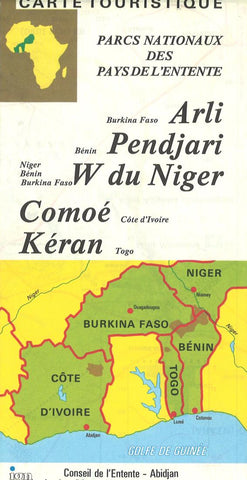
Africa, West Natl Parks = Carte touristique, parcs nationaux des pays de lEntente : Arli, Burkina Faso-Pendjari, Bénin-W du Niger, Niger, Bénin, Burkina Faso-Comoé, Côte dIvoire-Kéran, Togo
Double-sided map showing several national parks in the Benin/Niger/Burkina Faso border area, plus in Togo and Ivory Coast. The main map at 1:375,000 covers the W du Niger National Park and its neighbouring parks to the west: Pendjari and Arli. On the reverse at 1:250,000 are the Kéran NP in northern Togo, and the Comoé NP in northern Ivory Coast.
Road detail shows intermediate driving distances and distinguishes routes of “intermittent practicability”. National park and international boundaries are marked. Forest, plain and flooded areas are distinguished and hill-shading shows significant relief variations (although such detail is confined to within the national parks). Symbols denote various useful features and landmarks e.g. hospitals, telephones, post offices, petrol stations, airfields, hotels, campsites, viewpoints and historic sites, also selection of mammal and bird species inhabiting the area. Latitude and longitude margin ticks and intersections are at 30’ intervals a
- Product Number: IGN_WANP_84
- Reference Product Number: 2034291M
- ISBN: 9780783402772
- Date of Publication: 6/1/1984
- Folded Size: 8.66 inches high by 4.33 inches wide
- Unfolded (flat) Size: 34.25 inches high by 26.38 inches wide
- Map format: Folded
- Map type: Trade Maps - Park
- Geographical region: Benin,Burkina Faso,Cote d'Ivoire,Niger,Togo