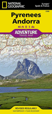
Pyrenees and Andorra Adventure Map 3308
• Waterproof • Tear-Resistant • Travel Map
National Geographic’s Pyrenees and Andorra Adventure Map provides global travelers with the perfect combination of detail and perspective in a highly functional travel tool. This map includes the locations of cities and towns with a user-friendly index, plus a clearly marked road network complete with distances and designations for roads and highways. Beaches and yachting harbors dot Spain and France’s Mediterranean coastlines while the location of golf courses, camping sites, waterfalls, caves, and ski areas make it easy to enjoy the region’s abundant outdoor activities. National parks, World Heritage sites, scenic viewpoints, antiquity sites, museums, and more are included, making it invaluable to travelers hoping to experience all the history, art, and culture the region has to offer.
The front side shows the country of Andorra and the eastern half of the Pyrenees including the cities of Narbonne, Carcassone, Pamiers, St-Gaudens,
- Product Number: NG_AM_PYR_22
- Reference Product Number: - None -
- ISBN: 9781566955409
- Date of Publication: 12/1/2022
- Folded Size: 9.45 inches high by 4.33 inches wide
- Unfolded (flat) Size: 37.8 inches high by 25.59 inches wide
- Map format: Folded
- Map type: Trade Maps - Travel
- Geographical region: Andorra,France,Spain