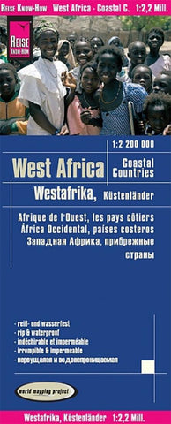
West Africa, coastal countries
Western Africas Coastal Countries at 1:2,200,000 on an indexed, waterproof and tear-resistant road map with topographic and tourist information, published by Reise Know-How as part of their highly acclaimed World Mapping Project. The map is double-sided to provide the best balance between a good scale and a convenient size sheet and covers countries from Senegal to Nigeria, Burkina Faso, plus southern Mali, with inset showing the Cape Verde Islands.
Detailed road network and railways are easy to see on a clear base which shows the area’s topography by altitude colouring with contours, spot heights, names of hill ranges, swamps, seasonal rivers, etc. Internal administrative boundaries are shown with names of the provinces. Road network includes unsurfaced roads and tracks, indicating locations of petrol stations and border crossings. A wide range of symbols highlights various places of interest, including UNESCO heritage sites, national parks and nature reserves, turtle protect
- Product Number: RKH_AFR_W_19
- Reference Product Number: 2331315M
- ISBN: 9783831774272
- Date of Publication: 6/1/2019
- Folded Size: 10.24 inches high by 4.72 inches wide
- Unfolded (flat) Size: 39.37 inches high by 27.56 inches wide
- Map format: Folded
- Map type: Trade Maps - Road
- Geographical region: Benin,Burkina Faso,Cameroon,Cote d'Ivoire,Gambia,Ghana,Guinea,Guinea-Bissau,Liberia,Mauritania,Niger,Nigeria,Republic of Cabo Verde,Senegal,Sierra Leone