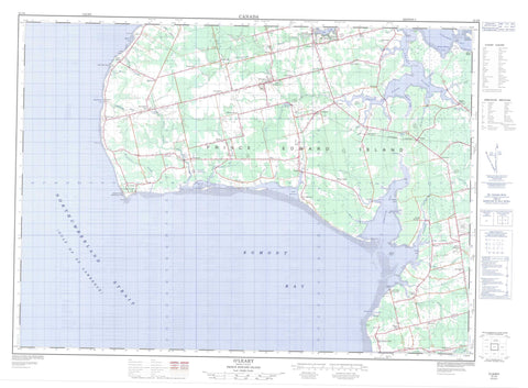
021I09 O Leary Canada topo map, 1:50,000 scale
021I09 O Leary NRCAN topographic map.
Includes UTM and GPS geographic coordinates (latitude and longitude). This 50k scale map is suitable for hiking, camping, and exploring, or you could frame it as a wall map.
Printed on-demand using high resolution, on heavy weight and acid free paper, or as an upgrade on a variety of synthetic materials.
Topos available on paper, Waterproof, Poly, or Tyvek. Usually shipping rolled, unless combined with other folded maps in one order.
- Product Number: NRCAN-021I09
- Parent Topo: TOPO-021I
- Map ID also known as: 021I09, 21I9, 21I09
- Unfolded Size: Approximately 26" high by 36" wide
- Weight (paper map): ca. 55 grams
- Map Type: POD NRCAN Topographic Map
- Map Scale: 1:50,000
- Geographical region: Prince Edward Island, Canada
Neighboring Maps:
All neighboring Canadian topo maps are available for sale online at 1:50,000 scale.
Purchase the smaller scale map covering this area: Topo-021I
Spatial coverage:
Topo map sheet 021I09 O Leary covers the following places:
- Black Banks Cove - Brae Harbour - Cascumpec Bay - Cascumpeque Bay - Dog Cove - Egmont Bay - Foxley Bay - Foxley Cove - Golfe du Saint-Laurent - Goose Harbour - Gordon Creek - Gordons Creek - Gulf of St. Lawrence - Howard Cove - Howards Cove - MacWilliams Cove - McWilliams Cove - Percival Bay - Stephen Cove - Wolfe Inlet - Enman Shore - Grande Digue Shore - MacWilliams Shore - McKies Shore - Portage Shore - Reillys Shore - Yeos Shore - Baptiste Point - Bells Point - Black Point - Black Point - Cape Wolfe - Carey Point - Elm Point - Gordons Point - Grande Digue Point - Hardy Point - Indian Point - Kellys Point - Lot 6 Point - McIsaac Cape - McNallys Point - Moores Point - Mossy Point - Poudre Point - Rock Point - Rocky Point - Sandy Point - Seal Point - Seal Point - West Point - West Spit - Détroit de Northumberland - Northumberland Strait - Lot 10 - Lot 11 - Lot 12 - Lot 13 - Lot 14 - Lot 15 - Lot 5 - Lot 6 - Lot 7 - Lot 8 - Lot 9 - Prince - Ballems Island - Bird Island - Brae Island - Prince Edward Island - Big Barachois - Foxley Pond - Frizzells Pond - Getsons Pond - Glenwood Pond - Leards Pond - MacWilliams Pond - McWilliams Pond - Milligans Pond - Portage Lake - Richards Pond - The Barachois - Higgins Wharf - Conway Sand Hills - Indian Point Sand Hills - Bloomfield Provincial Park - Cedar Dunes Provincial Park - Higgins Wharf Provincial Park - Mill River Provincial Park - Vanier Provincial Park - Île-du-Prince-Édouard - Prince Edward Island - Barachois Run - Baptiste Creek - Beatons Creek - Beatons River - Big Pierre Jacques River - Brae River - Canadian Creek - Carruthers Brook - Cross Creek - Cross River - Crossmans Brook - Daltons Brook - Dog Creek - Duck Creek - Enmore River - Foxley River - Freshwater River - George River - Little Duck Creek - Little Pierre Jacques River - Little Trout River - MacDonalds River - MacLaurins Creek - MacLeans Brook - MacWilliams Brook - Mary River - Maxime Creek - Mill River - Ox River - Oyster River - Perceval River - Percival River - Pierre Jacques River - Platt River - Pollard Brook - Portage River - Raphael River - Robb Creek - Robbs Creek - Sheep River - Stewarts Creek - Trout River - Cape Wolfe Rock - West Reef - Alaska - Beaton - Beaton Road - Beaton Road - Bethel - Black Banks - Brae - Brae Harbour - Cape Wolfe - Carleton - Cascumpec - Cascumpeque - Coleman - Derby - Dunblane - Duvar - Enmore - Forestview - Foxley River - Glenwood - Greenhill - Haliburton - Harmony - Hawthorne - Hebron - Higgins Road - Howlan - Inverness - Kelly Road - Knutsford - Little Pierre Jacques - Locke Road - Locke Road - Lot 10 - Lot 6 - Milburn - Mill Road - Milo - Mount Pleasant - Mount Royal - North Enmore - O'Leary Station - Portage - Roxbury - Springfield - Springfield West - Springhill - St. Anthony - St. Chrysostom - St. Chrysostome - St. Hubert - St. Philip - St-Hubert - St-Philippe - Unionvale - Victoria West - West Cape - West Devon - West Point - Woodbrook - Woodstock - Black Bank - Wolfe Marshes - Lady Slipper - Lot 11 and Area - O'Leary - Richmond