
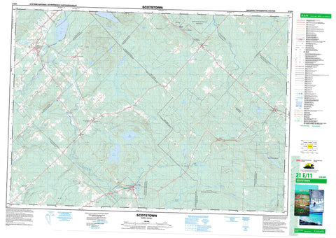
021E11 Scotstown Canada topo map, 1:50,000 scale
021E11 Scotstown NRCAN topographic map.
Includes UTM and GPS geographic coordinates (latitude and longitude). This 50k scale map is suitable for hiking, camping, and exploring, or you could frame it as a wall map.
Printed on-demand using high resolution, on heavy weight and acid free paper, or as an upgrade on a variety of synthetic materials.
Topos available on paper, Waterproof, Poly, or Tyvek. Usually shipping rolled, unless combined with other folded maps in one order.
- Product Number: NRCAN-021E11
- Parent Topo: TOPO-021E
- Map ID also known as: 021E11, 21E11
- Unfolded Size: Approximately 26" high by 36" wide
- Weight (paper map): ca. 55 grams
- Map Type: POD NRCAN Topographic Map
- Map Scale: 1:50,000
- Geographical region: Quebec, Canada
Neighboring Maps:
All neighboring Canadian topo maps are available for sale online at 1:50,000 scale.
Purchase the smaller scale map covering this area: Topo-021E
Spatial coverage:
Topo map sheet 021E11 Scotstown covers the following places:
- Scotstown - Bury - Dudswell - Hampden - Lingwick - Marston - Notre-Dame-du-Bon-Conseil - Saint-Alphonse - Saint-Ambroise - Sainte-Marguerite - Saint-Gérard - Saint-Janvier - Saint-Paul - Saint-Raymond-de-Pennafort - Stratford - Weedon - Whitton - Winslow - Barrage de Weedon - Barrage Vaseux - Barrage Walter-MacKenzie - Étang de l'Île - Étang Hind - Étang Mill - Étang Moose - Lac à la Biche - Lac à la Truite - Lac à Laprise - Lac Brochet - Lac Brochet - Lac Dell - Lac Dumoulin - Lac Elgin - Lac Gosselin - Lac la Loutre - Lac Legendre - Lac Louise - Lac Magill - Lac McGill - Lac McIver - Lac McKenzie - Lac McLeod - Lac Midas - Lac Moffatt - Lac Monty - Lac Orignal - Lac Roland - Lac Turcotte - Lac Vaseux - Lac Weedon - Lac Whitton - Petit lac Brochet - Petit lac Legendre - Petit lac Vaseux - Cimetière de Dell - Cimetière de Gisla - Cimetière McAuley - Les Trois-Moulins - Mont Aylmer - Circonscription électorale de Mégantic-Compton - Parc Central - Parc de récréation de Frontenac - Parc des Tilleuls - Parc Walter-MacKenzie - Zec de Saint-Romain - Bog Brook - Bog Brook - Otter Brook - Otter Brook - Rivière Albion - Rivière au Canard - Rivière au Rat - Rivière au Saumon - Rivière Blanche - Rivière des Indiens - Rivière Felton - Rivière Legendre - Rivière Noire - Rivière Rouge - Rivière Saint-François - Rivière Sauvage - Rivière Victoria - Rivière Whitton - Ruisseau à la Truite - Ruisseau au Castor - Ruisseau Beaver - Ruisseau Bonn - Ruisseau Bown - Ruisseau Brookbury - Ruisseau Caron - Ruisseau chez Baptiste - Ruisseau de la Languette - Ruisseau Dell - Ruisseau Dodge - Ruisseau Dutch - Ruisseau Ferré - Ruisseau Gunn - Ruisseau Isabel - Ruisseau la Loutre - Ruisseau la Loutre - Ruisseau Lingwick - Ruisseau Lingwick - Ruisseau McGill - Ruisseau McLeod - Ruisseau Moffatt - Ruisseau Moffatt - Ruisseau Mud - Ruisseau Tambs - Ruisseau Tupper - Ruisseau Turcotte - Ruisseau Valley - Ruisseau Weedon - Côte de la Felton - Pont McVetty-McKerry - Saint-Gérard - Weedon Centre - Canterbury - Dell - Domaine-Donald-Morrison - Fontainebleau - Gould - Gould Station - Le Domaine-Poisson - Les Pointes-à-Émile - Les Pointes-à-Thomas - McLeod's - Milan - Moulin-Legendre - Nantes - Pitouneville - Sainte-Marguerite-de-Lingwick - Sainte-Marguerite-de-Lingwick - Scotstown - Spring Hill - Stornoway - Tolsta - Village-Trahan - Weedon - West Keith - Marécage des Scots - Marécage Scotstown - Bury - Dudswell - Fontainebleau - Hampden - Lingwick - Marston - Milan - Nantes - Piopolis - Sainte-Cécile-de-Whitton - Saint-Romain - Stornoway - Stratford - Val-Racine - Weedon - Weedon


