
Mt. Toby (MA) Topographic/Hiking Map
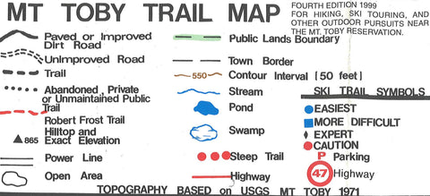
This hiking and topographic map covers Mt. Toby, the highest mountain in Massachusetts. The map shows hiking and ski trails, trail difficulty, land ownership (state vs. private), and extensive text on the reverse side.
- Product Number: CJR_MTT_99
- Reference Product Number: 2294075M
- ISBN: - None -
- Date of Publication: 6/1/1999
- Folded Size: 5 inches high by 6 inches wide
- Unfolded (flat) Size: 17 inches high by 19 inches wide
- Map format: Folded
- Map type: Trade Maps - Hiking
- Geographical region: United States
- Geographical subregion: Massachusetts


