
Channel Islands : national park & national marine sanctuary
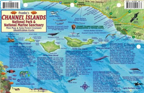
Franko’s Map of Channel Islands National Park is a miniature of the same map on side 1 of Franko’s Map of Channel Islands National Park & National Marine Sanctuary. It depicts the five islands, San Miguel Island, Santa Rosa Island, Santa Cruz Island, Anacapa Island, and Santa Barbara Island off the Santa Barbara and Ventura County coast in beautiful shaded relief. The area’s plentiful marine mammals are shown around the islands. These include whales, pinnipeds, and dolphins. A great white shark is also shown lurking beyond the rich pinniped rookeries. Descriptions of each of the islands educate the reader about what the island is like, especially in the underwater realm. The ocean depth contours are shown in fabulous shades of blues. One can envision that this used to be two large islands instead of five smaller ones just as the last great ice age ended, when the sea water levels were 200 to 300 feet lower.
Side 2 shows Franko’s Channel Islands Kelp Forest Creatures. Th
- Product Number: FM_CHIS_FISH_15
- Reference Product Number: 2043048M
- ISBN: 9781931494663
- Date of Publication: 6/1/2015
- Unfolded (flat) Size: 8.46 inches high by 5.51 inches wide
- Map format: Folded
- Map type: Thematic - Fish Cards
- Geographical region: United States
- Geographical subregion: California


