
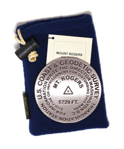
Mt. Rogers, VA Paperweight
3 1/4 inch diameter
Cast in fine pewter
Felt backing
With soft fleece pouch
In clear-vinyl covered box
PLACE NAME: Rogers
ELEVATION: 5729 ft.
COORDINATES: N36° 39 35 W081° 32 41
LOCATION: Virginia, USA
MARKERSLEUTH PHOTO CONTRIBUTOR: Ward Strang
Covered by a thick spruce-fir forest, the summit of Virginias highest peak offers no views, but the trails to the summit pass through open meadows and cross bald ridge tops offering far reaching vistas. There, you can experience some of the most spectacular scenery and rugged terrain in Virginia.
The Mount Rogers area is of great interest to geologists because it is the only place in the state that preserves evidence of ancient glaciation.
Mount Rogers is named after William Barton Rogers, a professor of natural philosophy and chemistry during the 1820s & 30s, who later became Virginias first State Geologist and also founded M.I.T.
In summer, this is a well-trav
- Product Number: GSU_PW_ROGERS
- Reference Product Number: 2290101
- ISBN: - None -
- Map format: - None -
- Map type: Accessories - Other Accessories
- Geographical region: United States
- Geographical subregion: Virginia


