
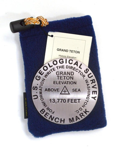
Grand Teton, Grand Teton National Park, Wyoming paperweight
3 1/4 inch diameter
Cast in fine pewter
Felt backing
With soft fleece pouch
In clear-vinyl covered box
PLACE NAME: Grand Teton
HISTORIC ELEVATION: 13,770 ft.
COORDINATES: N43° 44 28 W110° 48 09
LOCATION: Grand Teton National Park, Wyoming, USA
MARKERSLEUTH PHOTO CONTRIBUTOR: Dave Paisley, 1996
The Grand, flanked by the Middle and South Tetons, is the highest of more than 20 peaks over 10,000 feet in the Teton Range. The Tetons rise 7,000 feet from the valley floor. Their spectacular silhouette, shaped nine million years ago by the powerful forces of our dynamic planet, is beloved by all. Beginning in 1871, the Yellowstone-Teton region was surveyed under the direction of geologist and explorer-surveyor, Ferdinand Vandiveer Hayden. The Hayden survey is often credited with making the American people aware of the grandeur of the region and the need to preserve it.
- Product Number: GSU_PW_TETON
- Reference Product Number: 2306186M
- ISBN: - None -
- Map format: - None -
- Map type: Accessories - Other Accessories
- Geographical region: United States
- Geographical subregion: Wyoming


