
Antietam Battlefield : Sharpsburg, Maryland : 1862
The true watershed battle of the Civil War. Had Robert E. Lee won, foreign intervention might have resulted in Confederate independence.
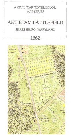
Style: Watercolor and colored pencil map showing crops, fences, houses, farms, watercourses, woods and significant terrain. No troop movements depicted. One side of the map features Morning Antietam Battlefield, Sharpsburg, Maryland, 1862 and represents the northern half of the field. The reverse side features: Afternoon Antietam Battlefield, Sharpsburg, Maryland 1862 and represents the southern half of the field. Text: The text includes a monograph describing the Maryland campaign and its Battle of Antietam. Packaged in a reusable sleeve.
- Product Number: MEM_ANTIETAM_93
- Reference Product Number: 2030568M
- ISBN: 9780783416717
- Date of Publication: 6/1/1993
- Folded Size: 9.06 inches high by 3.94 inches wide
- Unfolded (flat) Size: 18.9 inches high by 14.17 inches wide
- Map format: Folded
- Map type: Trade Maps - Historical
- Geographical region: United States
- Geographical subregion: Maryland


