
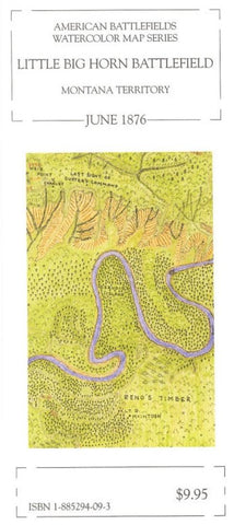
Little Big Horn Battlefield : Montana territory : June 1876
The most famous little battle in the world. Scale: 1= 1000
Style: Watercolor and colored pencil map showing terrain, watercourses and Sioux villages. Some troop movements depicted. Reverse side: Text includes an account of George Armstrong Custers brief Civil War career as a Topographical Engineer. Reproductions include the Culbertson Guidon (the first time ever published in full color), the 1877 Fouch photograph believed to be the earliest ever taken at Little Big Horn, a full-color Philo Clark Indian map and two black and white photos of pack mules and Custers quarters at Fort Abraham Lincoln.
- Product Number: MEM_LITTLE_96
- Reference Product Number: 2030569M
- ISBN: 9781885294098
- Date of Publication: 6/1/1996
- Folded Size: 9.06 inches high by 3.94 inches wide
- Unfolded (flat) Size: 29.53 inches high by 14.57 inches wide
- Map format: Folded
- Map type: Trade Maps - Historical
- Geographical region: United States
- Geographical subregion: Montana


