
1976 Portrait USA Map
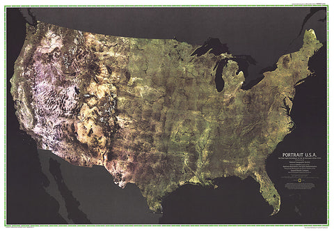
The first color satellite photomosaic of the 48 contiguous United States, this landmark map was published in July of 1976. The near-true color imagery creates a portrait of the patchwork quilt of the entire country. Trace the Mississippi river from its source to the Gulf of Mexico. See the deserts of New Mexico, Arizona, and California. Follow the Rocky Mountains through the western states. A cartographic benchmark, this map laid the groundwork for the many that have followed.
- Product Number: PODHNG_US_POR_76
- Reference Product Number: 2321647M
- ISBN: - None -
- Date of Publication: 6/1/1976
- Unfolded (flat) Size: 29.5 inches high by 42.5 inches wide
- Map format: Wall
- Map type: Trade Maps - Wall Art
- Geographical region: United States


